Field Guide to the Deep History Coast
Doggerland
There is a largely undiscovered and barely explored landscape just off Norfolk's Deep History Coast. A low landscape where people and wild animals lived that is now at the bottom of the North Sea. It existed for thousands of years from the time after the glaciers retreated but before sea level rose world-wide and flooded the land.
The existence of forests and landscapes below the sea had been suspected by Victorian geologists as their remains occasionally appeared around the coast of Britain at particularly low tides but they lacked the means to investigate effectively off-shore. Using the contours of the seabed they could surmise the outline of this land if sea level was lower than the present day but until the early years of the 21st century it had no features on the map. It was thought of as a part of the world that people just went through to get from Britain to the Continent, not a place where people would want to live. All that changed thanks to a team of archaeologists at Birmingham University who used modern computer techniques to reveal its secrets.
We now know that out there under the North Sea the is a whole country that Europe forgot that it had and all the evidence of what that world was like is out there just waiting to be discovered - a pristine archaeological and geological landscape.
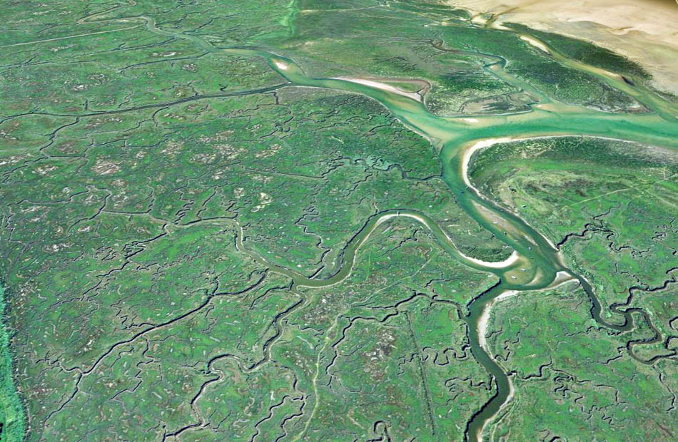
Doggerland was a rich landscape of coastlines, salt marshes, rivers and estuaries, lakes, hills and forests. Here was a very desirable place to live with abundant supplies of reed, wood, game, wildfowl, fish, shellfish and more.
In 1931 a clue came to light when the skipper of a trawler working 50 km off the Norfolk coast was clearing his nets of blocks of moorlog (hard peat) when his shovel hit on something hard. It turned out to be a barbed point made of antler. It found its way to the Norwich Castle Museum and recognised as belonging to a culture, known in Denmark, as the Maglemosan (Big Moss) that was dated to the then little known Mesolithic period. It seemed to indicate that people had once lived where there is now sea.
The rediscovery of Doggerland was an exiting achievement by Vince Gaffney, Simon Fitch and David Smith who were able to acquire access to a vast archive of seismic data from the oil and gas industry. They were able to extract a vast amount of information about the sediments just below the sea bed which they turned into maps and even three-dimensional digital models. They could recognise the features of that early Holocene landscape across an area of 24,000 square kilometres. Given this starting point researchers are now exploring this treasure-trove of pristine archaeology with diving and drilling programmes to find out more about it.
The bed of the sea also yields fossil bones of mega-fauna that are caught in the trawl nets of fishing boats, especially those of the Dutch fleet and a huge quantity of fossils of mammoth, bison, deer, scimita-toothed cats etc and even human remains have been recovered from the bed of the North Sea.
It is recognised that the North Sea has only been as full of water as it is now for relatively short periods in its long history and that the coast was frequently much further to the North. So now the term 'Doggerland' is being used for the area offshore anytime when sea level was low enough for Britain to be connected to the Continent.
References
Gaffney, V., Fitch, S. and Smith, D., 2009. Europe's Lost World: The rediscovery of Doggerland. Council for British Archaeology 202 pp.