Field Guide to the Deep History Coast
Wells-next-the-Sea: Wells Chalk Pit
Parking
On the north side of the A149 road is a lay-by opposite the entrance to the pit, or you can park in the entrance if the gate is open.
Access
Grid reference TF 9864 42624 for centre of the pit. This is no longer a working pit but is in the ownership of the Holkham Estate. Contact the estate survey James Bracey, Holkham Estate Office, Holkham, Wells-next-the-Sea, NR23 1AB, telephone 01328 710227. This is a Site of Special Scientific Interest, for its botanical interest, including beautiful helleborines which are found on the floor of the pit in July. A gun club uses the pit for shooting clays.
Coasthopper bus service timetable.
Geology
Wells Chalk Pit has important exposures of parts of the Upper Chalk not seen elsewhere in East Anglia and not found on the coast anywhere. The Newhaven Chalk Formation (Lower Campanian, zone of Gonioteuthis quadrata) is exposed in the walls of the pit, with the Wells Marl (equivalent to the Old Nore Marl of Southern England) well seen in the southeast corner. The marl is considered to be of volcanic origin and is correlated from England to northern Germany (e.g. Kronsmoor chalk pit, Schleswig-Holstein, which is 588 km distant from Wells Pit). The marl is an admixture of up to 10% clay (e.g. bentonite) and it is darker at the base. There are trace fossils in the form of squashed burrows within it. It also contains small crystals of the potassium feldspar sanidine, which holds out the prospect of getting an accurate date on the eruption. There are fossil fragments in the marl too.
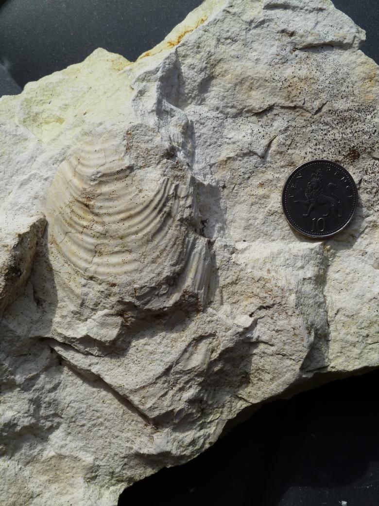
One of the key index fossils of this chalk is the bivalve Sphenoceramus (Inoceramus) lingua (see photo collected on a GSN field meeting with Professor Rory Mortimore 16.7.2011).
Fossils are difficult to find but there is a little seam of Echinocorys below the Wells Marl, which are similar to those found on the coast of Sussex below the Old Nore Marl. Other evidence, such as the Inoceramids suggests affinities with the chalk to the North. So this suggests that Norfolk is a transitional chalk province between the southern and the northern provinces.


The chalk here is fractured, with inclined conjugate fractures, just the same as you see on the South Coast and in Yorkshire, so it is extra-regional and is related to major tectonic forces affecting all of Europe in the post-Cretaceous. There is some horizontal movement as seen by the frequent offsetting of fractures across a marl seam. This is all overprinted by the intense small-scale fracturing caused by the Quaternary periglacial processes.
Diversion of the River Stiffkey
The River Stiffkey must once have made its way to sea by a more direct route east of Wells-next-the-Sea. But instead, at a point south of Warham it makes a sharp turn to the east and runs parallel with the coast. It cuts through hilly chalk country and occupies an incised valley in the vicinity of the village of Stiffkey itself before eventually finding its outlet into Morston Marshes. This is some 6.2 km east of where it once met the sea.
This behaviour is interpreted as diversion caused by glacial ice in the Devensian Glaciation, some 24,000-18,000 years ago, touching the North Norfolk coast and blocking its path.
Take a tour down the river Stiffkey with Google Earth: The Diversion of the River Stiffkey
Compiled by Martin Warren. Last updated 24.1.2011