Field Guide to the Deep History Coast
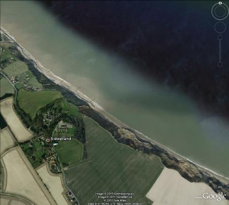
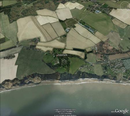
Overstrand to Sidestrand
Parking: at top of slip road at Clifton Way, Overstrand (TG 253405) or in lay-by west of at Trimingham (TG 274388).
Access: from the Overstrand end, down slip road east of village (TG 253406), then walking along the beach as the tide falls. There are gaps in the groynes you can walk through but sometimes these sometimes contain inconvenient seawater puddles, so wellington boots might be handy to avoid wet feet. On the return journey the rising tide may prevent the use of thee gaps but it is normally possible to walk on the landward side of the revtment, although it is harder walking on the pebbles and stones.
From the Trimingham end, an informal cliff path down the cliff is reached via a footpath from the long lay-by on the B 1159 (TG 274388), across a field and through a small wood. This approach is best avoided in wet seasons, as the cliff is made treacherous by cliff falls and mud slides that can envelope a person up their thighs! Beware high tides will reach the cliff base and you can be cut off! A visit is best at, or just after, full moon or new moon when spring tides give low water in the middle of the day and maximum beach exposure. The Cliff Top Café at Overstrand is a joy not to be missed.
Geology
A wonderful stretch of beach and spectacular geological section that will reward the effort of reaching it. This is a critical section for research into many aspects of Pleistocene and Cretaceous geology.
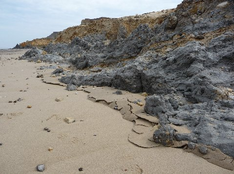
The slip road at the Overstrand end cuts through glacially deformed and tilted rafts of Lower Maastrichtian Chalk, embedded in till. Note the marl bands in the Chalk about 3 cm thick. These mark slippage planes during glaciotectonic movements and the beds in the Chalk are repeated due to over-thrusting. Turn right at the bottom of the road and walk SE. This is made difficult by cliff falls and revetments but is usually passable except at high water. Part of the Chalk previously encountered is seen below the road, resting on till. A channel filled with course gravels cuts into it and may well be sub-glacial in origin. A few metres SE the cliff is composed of First Till and Intermediate Beds (glacial lake clays) resting on the Cromer Forest-bed. The lake clays are sheared by thrusting and the thrust planes curl up towards the cliff top with a vergence to the SE.
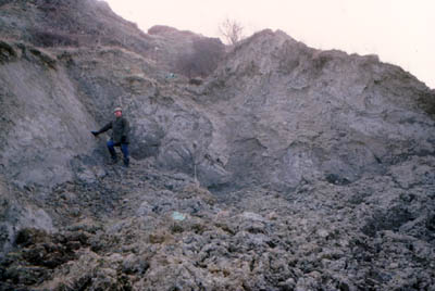 Note the style of cliff erosion in these impermeable clays, which is a continuous slurry rather than infrequent major slips. A major scheme to stabilise these cliffs went in in 1995.
Glacial thrusting during the Anglian glaciation has pushed the clays from right to left in the photograph. The leading edge of the thrust has curled up towards the sky and John Clayden is leaning on the now steeply dipping bedding plane. When the sea eats into the toe of the cliff, gravity takes over and the cliff becomes unstable. To the alarm of the residents above the slippery clays just slide back the way they came 400,000 years ago.
Glaciotectonics
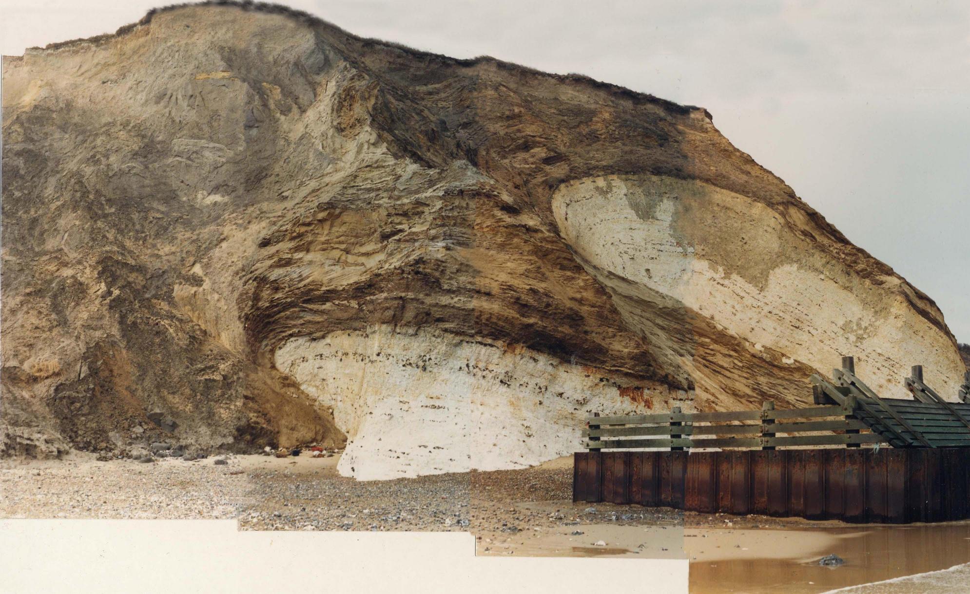 From about 250m from the slip road is a series of glaciotectonic Chalk 'rafts' (low angle thrusts), emplaced by ice-push movements. Two such rafts are spectacularly displayed in the cliffs, dipping NNE. On the beach for the next 800m eastwards there are wave-cut platforms of chalk, being the eroded remains of these and three further rafts.
If you think about it, none of the cliff here is actually in situ. All of it as far as Trimingham has been moved a short distance by glacial thrusting.
References
Burke, H., Phillips, E., Lee, J. R. & Wilkinson, I. P., 2009. Imbricate thrust stack model for the formation of glaciotectonic rafts: an example from the Middle Pleistocene of north Norfolk, UK. Boreas, 10.1111/j.1502-3885.2009.00085.x ISSN 0300-9483
Cromer Forest-bed
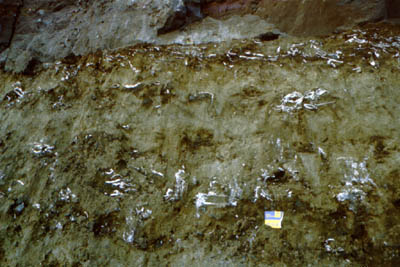
The Unio Bed at Sidestrand.
This fossiliferous mud containing freshwater mussels (Unio sp.) is interesting to current research for being of a broadly similar age to the West Runton Freshwater Bed (which yielded the celebrated elephant Mammuthus trogontherii) and yet its fossils (especially the shells) indicate that it is younger, giving us a different window on the 'Cromerian' complex. Interest has been sharply focused the shells and the water voles of the 'Cromerian' because in this stage the antique form called Mimomys, with rooted molar teeth, is replaced by the ancestor of our modern water vole Arvicola, with continuously growing teeth. This turns out to be an Arvicola fauna'
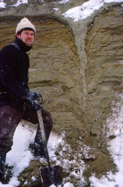 Left: A fossil ice wedge cast developed in Cromerian tidal sediments is filled by sands of presumed early Anglian age.
Within the Cromer Forest-bed sequence there are several climatic cycles. The presence of sediments affected by cold climate is dramatically demonstrated by occasional fossil ice wedge casts like this one. Repeated freezing and thawing at the surface of permafrost creates polygonal patterns of ice-wedges. The soil is forced apart by the expansion of ice and when it melts the sediments fall in from above to form the fossil ice-wedge cast.
The author and a fossil ice-wedge cast. Photo: Paul Whittlesea
Wroxham Crag
Wrapped around glaciotectonised chalk rafts are also several metres of the Wroxham Crag (formerly the Weybourne Crag) and these are occasionally seen close to the chalk shore platforms at the Sidestrand end. At the opposite end, near the path up to Trimingham one usually finds large numbers of flatish round clay ironstone pebbles and these are very likely betraying the presence of Wroxham Crag (and probably a buried Chalk raft) not far below the beach surface.
Cliff erosion
 The cliff erosion all along this section is fierce, with an average of 3m or more lost to the sea each year. A variety of slumping styles is exhibited from massive rotational slips of millions of tons to daily seepage via trickles of muddy slurry. After an initial 'shoot' that spreads across the beach, the sea erodes the talus and takes the debris south-eastwards towards Yarmouth by longshore drift. The continuous supply of fresh material is vital to maintain healthy beaches. If the cliff is protected the beaches become denuded and lowered, which only allows the sea to attack the coastline with renewed vigour.
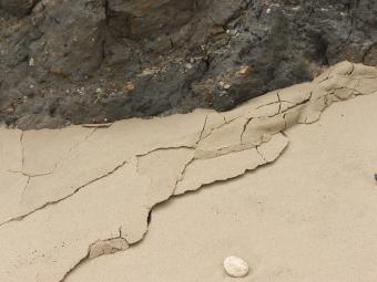 Slips continue to flow, creeping at several centimetres a day, for months or even years after their initial failure. In so doing they can resemble valley glaciers and demonstrate features such as lateral moraines, bergschrund, crevasses, 'ice-falls' and a toe that continues to press forward across the beach (see photo) like an advancing glacier. Though the tide smoothes out the beach every day, within a short while the sand in front may be bulldozed up by the advancing mud. The way in which sheets of sand are thrust forwards and upwards is a miniature model of the processes that once occurred in the Anglian glaciation, when ice from the north-northwest induced pro-glacial thrusting that buckled and uplifted chalk and other pre-glacial sediments, as spectacularly exhibited in the structural geology of the whole Sidestrand section.
Chalk
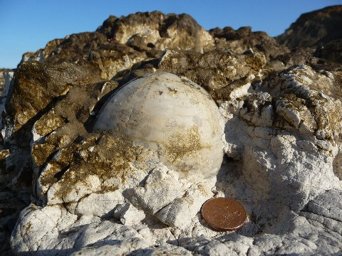
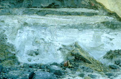
The Chalk here is only visible due to glaciotectonics that have elevated rafts of chalk and super-incumbent crag above their natural position of about 10m below sea level. The Chalk here is Maastrichtian in age, including the Porosphaera Beds and the Sponge Beds. This is some of the youngest Chalk available in the British Isles, rich in fossils of great diversity and of relatively shallow facies, with hard grounds. The stratigraphy at Sidestrand overlaps with the even younger Chalk rafts at Trimingham. There are good opportunities for serious collecting of the fossils when the Chalk platforms are uncovered, but groynes and revetments have raised beach levels so the exposure is infrequent today. In the cliff the Chalk rafts are accompanied by up to 5m of Weybourne Crag and Cromer Forest-bed. These deposits are perhaps the best available for the study of the crag. The shelly marine sands contain teeth of voles, lemming and desman, which may be recovered by sieving. In the beach the Chalk rafts are surrounded by similar deposits but are only exposed after a tidal scour.
Poppyland and the Garden of Sleep
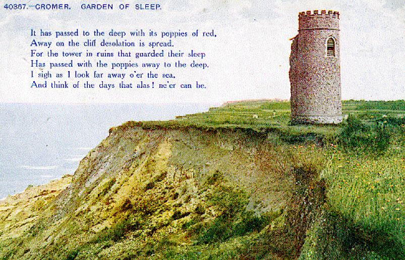 The London journalist and theatre critic Clement Scott popularised the Cromer area under the name of Poppyland. Symbolic of this area was a lonely church tower standing at the cliff edge, its nave and chancel dismantled but its graveyard remaining amongst the cornfields. He dubbed this the Garden of Sleep and it became a celebrated landmark and even inspired a song with a haunting melody.
The tower fell over the cliff in 1916 and its remains slowly eroded on the beach. Several cottages in Tower Lane have followed it over the years and pieces of brick, pipe and flint masonry can sometimes still be seen on the beach.