Field Guide to the Deep History Coast
Sidestrand to Trimingham
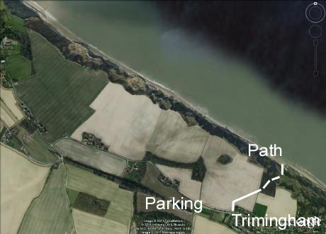
Parking: For an approach from Overstrand, park in Clifton Way, Overstrand and access the beach down the slip road. Alternatively for an approach from the Trimingham end park beside the B1159 (coast road), in a long sandy lay-by at the west side of Trimingham village (by the 30 mph signs as you enter the village from Cromer) at TG274389.
Access: the safest access to this section nowadays is from the Overstrand end. NNDC have provided a shortcut over and around the rock armour at the foot of the Clifton Way geo-engineered landslip. They have also created gaps in the groynes, making it much easier to pass along the beach from Overstrand to Sidestrand. Alternatively, for a wilder way down, go to the west edge of Trimingham village, park in the sandy lay-by and take the footpath across the field to a square plantation on the cliff edge (see top of photo). Pass through this copse and clamber down the 60m cliff to the beach. Warning: the cliff becomes very unstable after wet weather and the path may become dangerous, impassable or may disappear altogether. You can sink up to your thighs in mud flows. There are no facilities here, nor quick rescue. Network coverage for mobile phones is poor or nil. Also used occasionally by nudists. But it is probably the best beach in Norfolk for geology and the most dramatic scenery.
Geology
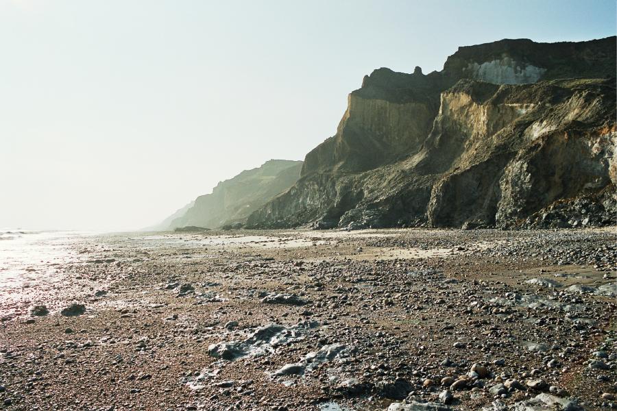
 The section at Trimingham is the wildest in Norfolk and with the highest cliffs on the East Coast. At this point the Cromer Ridge meets the coast and shows, in cross section, the materials of which the ridge is composed and the nature of it's creation. The structural geology is dominated by pro-glacial thrusting which has occurred at the margin of an advancing ice-sheet in the Anglian glaciation. Rafts of pre-existing materials such as chalk, Crag and Cromer Forest-bed sediments and earlier glacial sediments have been dislodged in thrust sheets and pushed forwards. Where the thrust has turned upwards it forms a ramp and one sheet is thrust up over another.
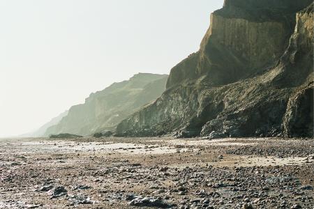
Glacial deposits
The Cromer Till
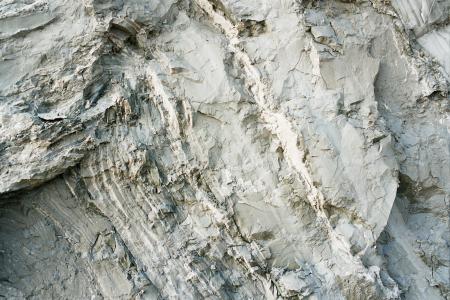
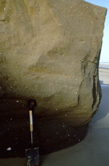 The lowest of the Cromer Tills at Trimingham is a very compact and tough diamicton, which, due to its resistance to erosion, forms steep sections of cliff at beach level. When above the beach it makes a prominent step in the cliff
profile. In it's upper parts, the till shows evidence that the icesheet was floating from time to time, and till was laid down under water. It shows horizontal banding, with drop stones and inter-leaving with sandier water-laid deposits that contain ripples.
The lowest of the Cromer Tills at Trimingham is a very compact and tough diamicton, which, due to its resistance to erosion, forms steep sections of cliff at beach level. When above the beach it makes a prominent step in the cliff
profile. In it's upper parts, the till shows evidence that the icesheet was floating from time to time, and till was laid down under water. It shows horizontal banding, with drop stones and inter-leaving with sandier water-laid deposits that contain ripples.
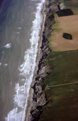
The entire Sidestrand-Trimingham section is involved in deformation named by Jane Hart as the 'Trimingham disturbance'. This is characterised by large-scale open folding resulting from horizontal forces. Hart interprets this as pro-glacial thrusting, giving rise to low-angle pro-glacial thrusts and folds. Closely related, and more proximal to the ice is the set of conspicuous 'rafts' of Chalk and Lower Pleistocene sediments to the west at Sidestrand. We now see a distorted view of these structures, as coastal erosion is cutting obliquely to the direction of thrusting but the result is nevertheless very dramatic.
The till is dark brown in colour, sandy in texture with conspicuous, but relatively small, chalk and flint pebbles, cockle shells and erratics of Jurassic clay ironstones and crystalline igneous and metamorphics. Ice-scratched and faceted boulders are not uncommon, especially amongst the more far-travelled erratics. The larger and more resistant boulders end up on the foreshore and sink to the lower levels of the mobile beach material.
Intermediate Beds
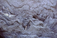
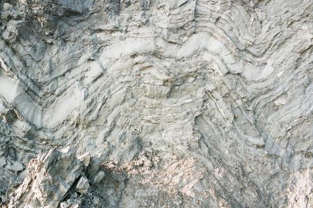
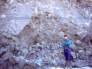 The lowest till is succeeded by waterlain sediments named the Intermediate Beds by the Victorian geologist Clement Reid, who surveyed this area for the Geological Survey of Great Britain. It is now recognised they were laid down in a temporary glacial lake - Lake Trimingham - by turbidity currents emanating from an inflow to the southeast. The sequence is rhythmic, with beds increasing in thickness upwards. The lower part of each rhythm is paler and slightly coarser than the top. These are interpreted by Hart as annual rhythms and she has counted approximately 2000 of them, suggesting the duration of this lake was in the order of two millennia.
Glaciotectonics
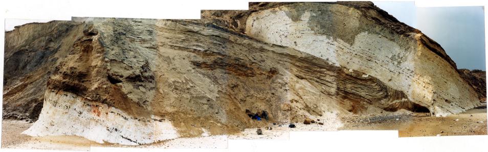
The reason that this section is the most spectacular on the whole of he East Anglian coast is that it represents a cross-section through an enormous glacial feature - the Cromer Ridge. Its internal structure is laid bare in this section and we can see very clearly the forces that have been at work to compress and shear the geology, to fold and to thrust, thickening the pile and creating Norfolk largest topographical feature.
Everywhere you look there is evidence of the compression. The finest examples of glaciotectonic structures are the imbricate thrust stack on the Overstrand-Sidestrand border, which I would like to name as the Mill House Thrust Stack and towards the other end of the section are the folded glacial lake clays, with their incompetent 'ptygnatic' folding.
Post-Anglian deposits
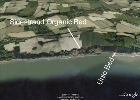
The Sidestrand Organic Bed

This critical Sidestrand-Trimingham cliff section includes an organic horizon - the Sidestrand Organic Bed, Trimingham Lake Bed (technically it is in Sidestrand parish) or Sidestrand Cliffs Formation - and it helps to determine the age of the deposits here and also the age of the deformation. It was discovered by Jane Hart in 1983 and described in her PhD thesis in 1987. About 2m below the top of the cliff two units: a basal inorganic horizon and above it an organic horizon that has a sharp lower boundary. They lie in a hollow with an irregular base that has two low points. Pollen samples were analysed by Sylvia Peglar at Cambridge University and were dominated by grasses but also included sedges (Cyperacae), and birch (Betula) with small willow (Salix) and pine (Pinus). There was also sea buckthorn (Hippophaë), juniper (Juniperus) and possibly spruce (Picea). The herb pollen includes a range of plants characteristic of a treeless environment, e.g. buttercup (Ranunculus), meadow rue (Thalictricum) and umbellifers (Umbelliferae). There are also shallow water and damp ground plants.
This deposit is interpreted as a low energy water body, such as a kettle hole fill, that spans the late glacial to the pre-temperate zone of a Middle Pleistocene interglacial stage. The presence of Hippophae pollen and a distinctive Middle Pleistocene ostracod suggested that this was part of the early Hoxnian Interglacial substage Ho 1 or the Anglian Late glacial, substage LAn. The deposits have little or no deformation. Thus, the deposits of the entire cliff and the deformation are demonstrably pre-Hoxnian in age.
The above conclusion was corroborated by Preece and others using molluscan evidence and clinched by data obtained by Kirsty Penkman's very refined intra-crystalline amino-acid racemisation analyses. They concluded that the 'Trimingham Lake Bed (Sidestrand Cliffs Formation)' as they called it, had accumulated during MIS 11, which equates to the Hoxnian. Thus all the glacial deposits predate MIS 11. The Sidestrand Unio Bed below the glacial sequence was also demonstrated to be younger than the West Runton Freshwater Bed on palaeontological grounds. Thus the Anglian glacial sequence is sandwiched and concluded to be MIS 12, as it was classically believed to be.
References
J. Hart, 1987. The Genesis of the North East Norfolk Drift. PhD Thesis, University of East Anglia
J.K. Hart and S.M. Peglar, 1990. Further evidence for the timing of the Middle Pleistocene Glaciation in Britain. Proceedings of the Geologists' Association. Volume 101, Issue 3, 1990, Pages 187-196
Jonathan R. Lee, 2009. Jonathan Patterns of pre-glacial sedimentation and glaciotectonic deformation within
early Middle Pleistocene sediments at Sidestrand, north Norfolk, UK. Proceedings of the Geologist's Association, 2009, Volume 120, pages 34-48.
R.C. Preece, 2001. Molluscan evidence for differentiation of interglacials within the 'Cromerian Complex'. Quaternary Science Reviews
Volume 20, Issues 16-17, October-November 2001, Pages 1643-1656 European Quaternary Biostratigraphy
Richard C. Preece, Simon A. Parfitt, G. Russell Coope, Kirsty E.H. Penkman, Philippe Ponel, John E. Whittaker, 2009. Biostratigraphic and aminostratigraphic constraints on the age of the Middle Pleistocene glacial succession in north Norfolk, UK. Journal of Quaternary Science. Volume 24, Issue 6, pages 557-580, September 2009.