Field Guide to the Geology of North Norfolk
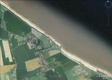
Happisburgh
Parking: on the cliff top public car park (pay and display, with toilets) in Beach Road, Happisburgh NR12 0PP at TG38433083.
Access: leave the car park via a kissing gate in the NW corner and go down an earthen ramp to the beach
Geology
Glacial geology
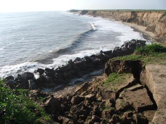
The cliffs are composed almost entirely of glacial and related sediments, with three diamicton units interbedded with sorted sediments. Happisburgh Till at the base, followed by Ostend Clay, then Walcott Till, Mundesley Sands and Bacton Green Till. In the Happisburgh area the glacial sediments are much less deformed than they are further northwest on the coast, beyond Mundesley. The lowest diamicton, the Happisburgh Till, appears to have been deposited subaqueously at first but as the glacier grounded the till accumulated by lodgement and subglacial deformation by ice moving from the northeast to the southwest. The lower contact, with pre-glacial sediments (which West referred to the Pastonian stage) is sharp. Its upper surface is undulating and fluted. The basins between the ridges are filled with clays and sands, sometimes ripple-marked, indicating shallow water sedimentation in a lake with a flow from SSE to NNW. The Ostend Clay is interpreted as turbidite deposits on the bed of a glacial lake.
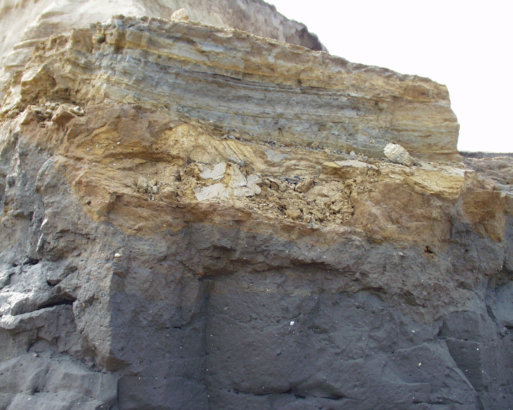 Ostend Clay resting on Happisburgh Till | 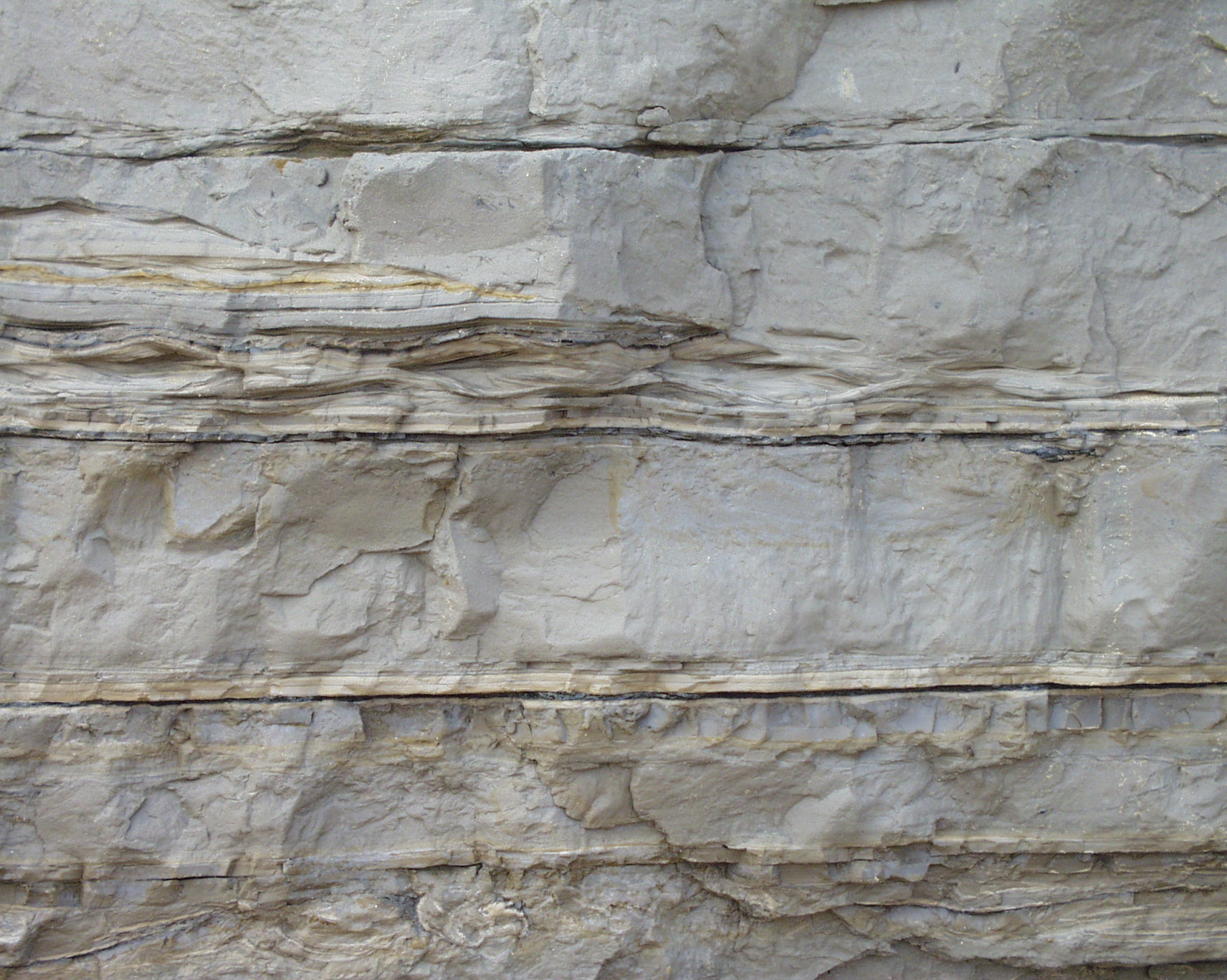 The Ostend Clay consists of laminations and beds laid down by turbidity currents in a glacial lake. |
Pre-glacial geology
The beds below the Happisburgh Till comprise sands, organic muds and gravels of the Cromer Forest-bed Formation, which locally have been named the Hill House Formation. They are interpreted as representing tidal sediments laid down at the mouth of a wide, slow and constantly flowing river thought to be the ancestral River Thames whose deposits can be traced across southern Hertfordshire, northern Essex and southern Suffolk, on a more northerly route than the Thames today. Structurally they have been affected by the passage of the Happisburgh Till glacier which caused low angle thrusting and faulting in their uppermost parts.
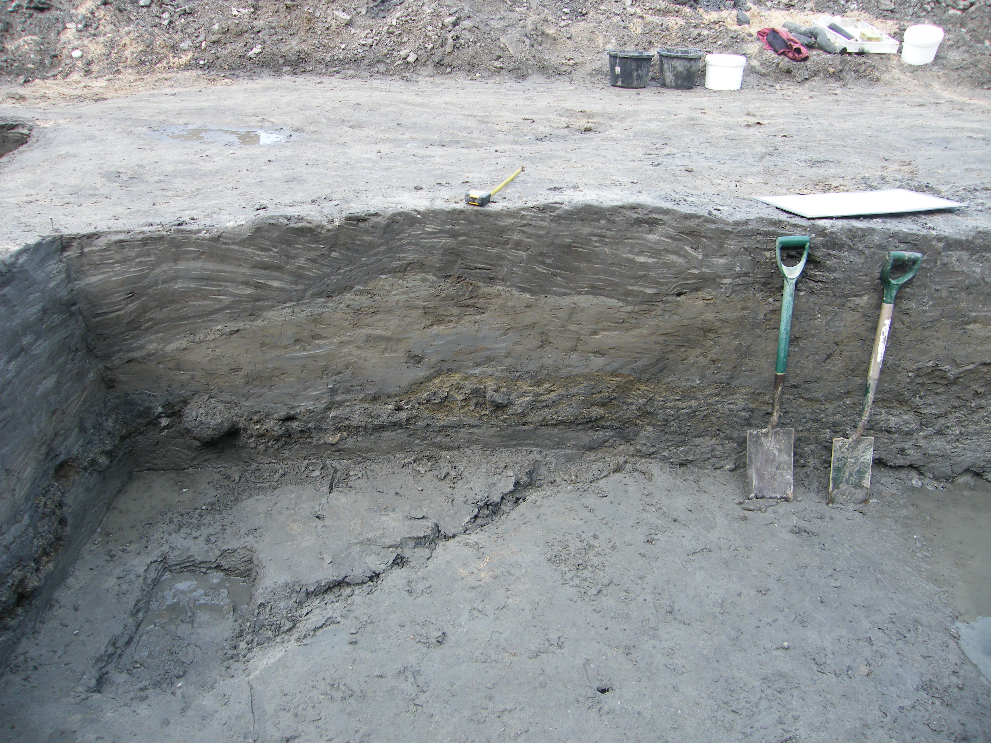 Hill House Member (Cromer Forest-bed) |  Gravels of the Hill House Member |
References
Lunka, J.P., 1988. Sedimentation and deformation of the North Sea Drift Formation in the Happisburgh area, North Norfolk. In Groot, David G. (ed.) Glaciotectonics Forms and Processes. A.A. Balkema; Rotterdam pp. 109-122
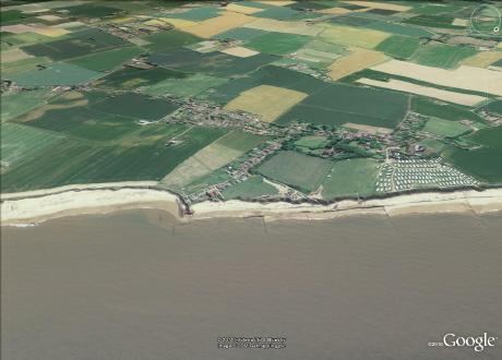
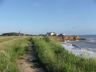
Coast erosion
The village of Happisburgh is severely threatened by rapid cliff erosion. To the south of the village in particular a deep embayment has been created. Roads and houses are being lost to the onslaught.

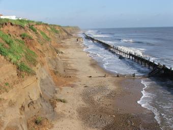
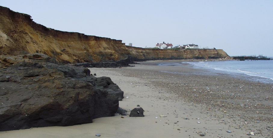
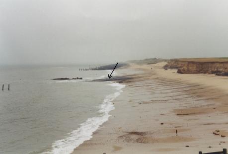
In the distance a World War 2 pill box lies where it fell as a result of cliff retreat. The lower cliff is composed of Happisburgh Till, which rests on shallow marine and intertidal sediments (below the beach). Archaeological excavations in 2007 have revealed archaeology, including a handaxe (British Museum), flint flakes and a core. Early indications are that this is extremely early, older even than discoveries at Pakefield in Suffolk.
The embayment south of the village retreated at an alarming rate in the 1990s and 2000s. The raised flatforms on the foreshore are composed of Happisburgh Till.
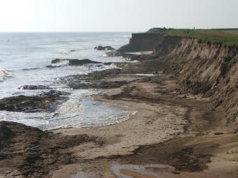
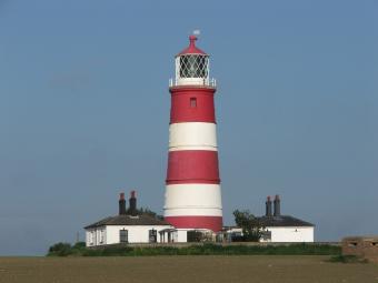
Happisburgh Lighthouse was 322.77m from cliff edge to the corner of the surrounding wall in 1886 (O.S. First Edition 6in to the mile). By 1988 this had reduced to 223m. The measurements from Google Earth are as follows: in 2006 it was 193m; in 2015 it was 176m. My latest measurement on the ground (11 February 2017) was 172.4m. At the current rate of erosion (2m per annum) the lighthouse will be on the brink at the end of the present century.
The social consequences of coast erosion are serious and politically charged. Here is a Youtube clip about the village and its plight. There is some small solace in a policy of North Norfolk District Council, called Pathfinder which, through government assistance, provides financial assistance to those affected by the erosion to purchase land and some guarantees of planning consent for alternative homes to be built in the neighbourhood.
See also the British Geological Survey website about coastal erosion at Happisburgh.
Archaeology
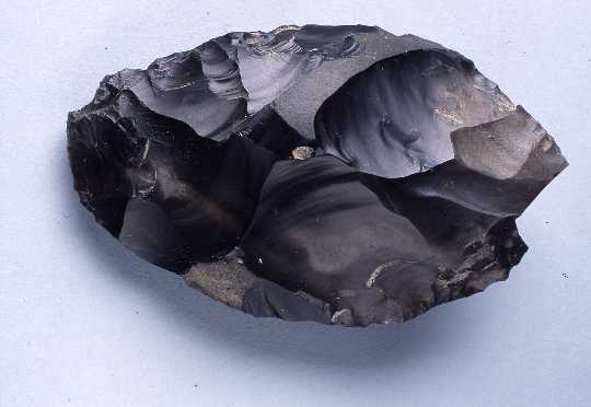
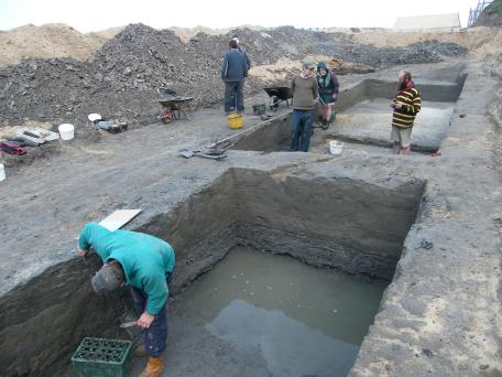
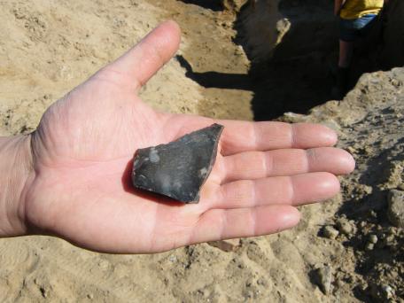
In March 2000 while walking the beach Mike Chambers discovered a hand axe embedded in mud exposed below the high water mark on the foreshore south of Happisburgh village. He took it to Cromer Museum and a new chapter in archaeological research began. It was recognised as a significant find, and field investigations soon followed. This was a beautifully made and fresh Palaeolithic flint handaxe that had been found in primary context in an organic mud of the Cromer Forest-bed, below the glacial deposits. It was the first unequivocal pre-Anglian tool to be found in Norfolk. Field investigations discovered flint flakes and cut-marked bone fragments which confirmed the deposit to be a pre-Anglian primary context with evidence of hominin (early human) activity. The handaxe site itself has been subject to continued erosion and the cliff retreat has been rapid, making it less accessible as time goes by.
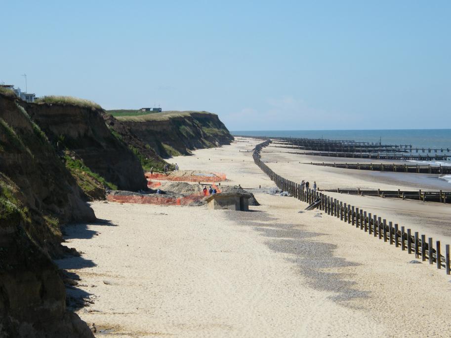
The British Museum and the Ancient Human Occupation of Britain group (AHOB) lead by Chris Stringer, with Nick Ashton, Simon Parfitt and others has undertaken summer excavations to understand the context of this site, particularly to the north of the handaxe site. They have scraped back beach sand and dug trenches into the laminated tidal sediments beneath to understand the geology and look for further evidence. It is now recognised that these overlapping channel deposits (Hill House Formation, named after the local pub) belong to the lower reaches of a major river. By the clast lithological analysis it is reckoned to be the River Thames, which formerly flowed across southern Hertfordshire, Essex, and roughly parallel with the coasts of Suffolk and Norfolk, with some input from the now extinct Bytham River flowing from the English Midlands. Happisburgh lay on the northern shore of the river and hominins visited there repeatedly, bringing flint tools to the site and discarding them.
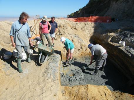
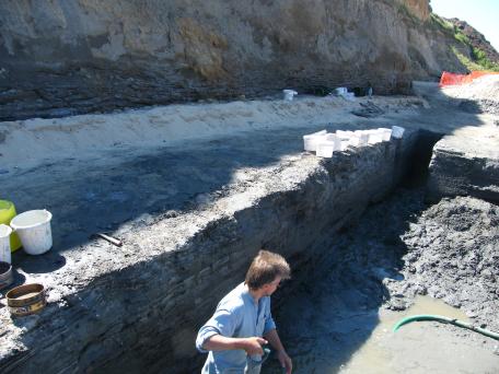
The dating of the site has been an important factor. Fossils, especially the voles, provide one line of evidence and palaeomagnetism another. The plant taxa include Tsuga (hemlock) and Ostrya type (hop-hornbeam type), which are unknown in Europe beyond the Lower Pleistocene. The fauna contains two species of Mimomys, the antique form of water vole (as opposed to Arvicola, its descendent), Mammuthus cf. meridionalis (Southern elephant), Equus suessenbornensis (extinct 'horse'), Cervalces latifrons (extinct elk), Cervus elaphus (red deer) and 'advanced' forms of Microtus (voles). The natural remanent magnetism is very significantly reversed compared with the modern day (magnetic compasses would have pointed south). Taken together these lines of evidence indicate that these sediments below the beach, which are older than the site of the handaxe, are at least 780,000 years and possibly as old as 990,000 years. This puts back the date of the earliest known humans in Britain by at least 280,000 years, making Happisburgh the oldest evidence of hominins in northern Europe. It also indicates that since the climate was not significantly warmer than the present day (from beetle and other evidence) these hominins may have had physical adaptations, seasonal migrations or technologies that allowed them to survive further north than previously thought possible. It begs questions about the possibility of hunting techniques, use of clothing, building of shelters and the use of fire but so far there are no answers. Excavations in search of the organic evidence will continue in 2011.
Earliest human footprints discovered at Happisburgh
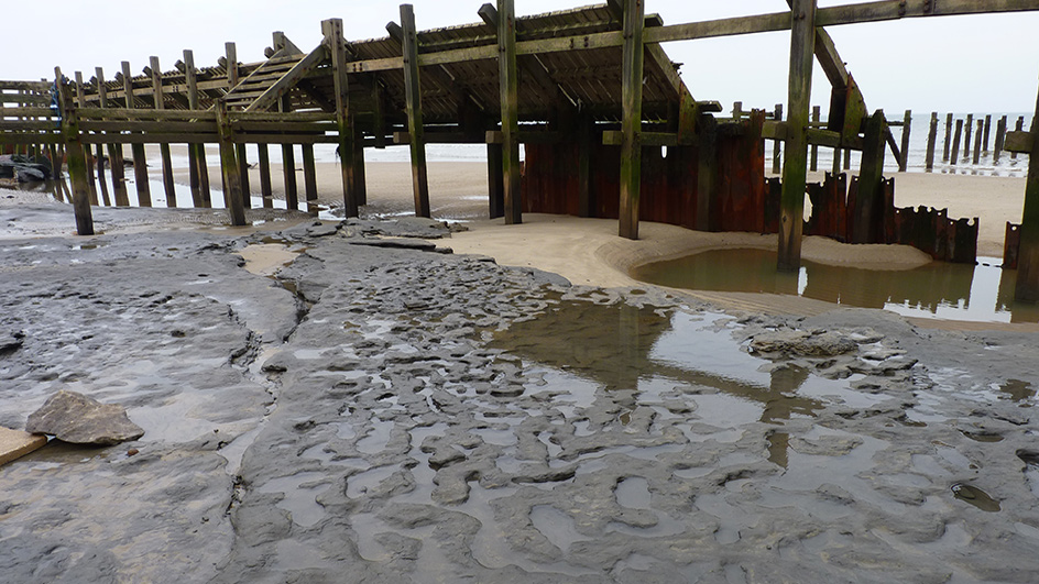
Photo: British Museum
In early February 2014 the news was broken that human footprints had been discovered the previous May in sediments of the ancient River Thames on the foreshore at Happisburgh. These are the oldest known human tracks outside of Africa. See the British Museum video about the discovery and subsequent research to verify their identity.
Professor Russell Coope
I was very saddened hear of the death on 26 November 2011 of Professor Russell Coope, the fossil beetle specialist. I first met him as a museology student in 1975 and have had the enormous pleasure of collaborating with him on sites around Norfolk and we have shared a table in the pub on many occasions. I last met him at Happisburgh in 2010, where he was participating in the investigation of the hominin sites there. We also enjoyed a fairly alcoholic evening then too. I am pleased to say that I once recorded a discourse on the beetles from the Happisburgh excavations on 26 June 2009. This was typical Russell Coope and you can view a slideshow as you listen to his impromptu talk by clicking on the image below.
Professor Russell Coope 1930-2011: Obituary
What beetles can tell us
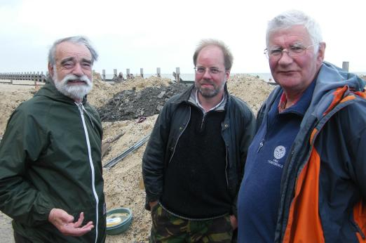
Russell Coope (left), Simon Parfitt (centre) and Peter Norton at Happisburgh 2010. Click here to hear Russell's impromptu talk on the usefulness of beetles in the environmental interpretation of the Cromer Forest-bed deposits at Happisburgh.
References
Parfitt, S.A., Ashton, N., Lewis, S.G., Abel, R.L., Coope, G.R., Field, M.H., Gale, R., Hoare, P.G., Larkin, N., Lewis, M.D., Karloukovski, V., Maher, B.A., Peglar, S.M., Preece, R.C., Whittaker, J.E., & Stringer, C., 2010. Early Pleistocene human occupation at the edge of the boreal zone in northwest Europe. Nature Vol. 466. 8 July 2010 229-233
Volcaniclastics amongst the rock armour
The cliffs at Happisburgh adjacent to the village are now protected by rock armour. The chief rock employed in the past for this kind of work has been larvikite, quarried from the west of Larvik in Oslofjord, Norway. Nowadays however the preferred stone is from Bardon Hill Quarry in Leicestershire. This is an andesitic volcanic complex emplaced in the late Pre-Cambrian when Leicestershire was an island arc above a subduction zone, analogous to the islands of the Caribbean today, particularly the island of Montserrat which erupted violently in 1995. Most attractive amongst the rock armour on Happisburgh beach is Bardon Breccia, a volcaniclastic rock that displays beautiful sedimentary structures (e.g. graded bedding) and micro-faulting caused by ash and bombs falling into water. These are evidence of violent explosions that shattered rock into sharply angular pieces to create a breccia (pronounced brech-ee-a). The colours are rather good too. See also East Runton-Cromer section of the Fieldguide for even more spectacular rocks from Bardon Hill.
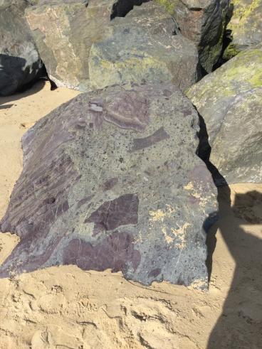
Bardon Breccia. Photo courtesy of Mike Mansfield, taken on a Geology Walk, 2016.
Compiled by Martin Warren. Last updated 18.10.2021