Field Guide to the Geology of North Norfolk
Beeston - West Runton
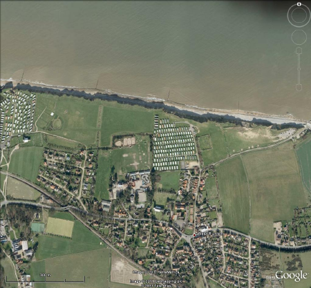
Parking: For access from the east end of the section there is a large car park at West Runton beach (Woman Hythe) sign posted from village (TG 184432). The proprietor makes a small charge, payable at the cafe or to an attendant in the season. No charge in winter. From the west there is street parking at the top of Cliff Road, by the Putting Green. A footpath beside the Putting Green and then steps lead down to the beach. Also free parking at Beeston Regis church, then walk around the east end of churchyard and make your way westwards along the cliff to the excellent private steps and down the beach.
Access: best from West Runton Gap (Woman Hythe). Alternatively from Sheringham end by walking eastwards along Promenade. Also possible from private steps down from Beeston Regis Caravan Park near the west end of the section but these steps are vulnerable to storm damage from time to time. They were intact when last inspected, February 2017.
Geology
 towards Beeston Regis")
View of the beach from West Runton (Woman Htythe) towards Beeston Regis in 2011. In the foreground the sand belongs to a tectonic basin of outwash within the Anglian glacial sequence. Beeston Hill (Beeston Bump), a glaciotectonic feature, is in the distance. The wooden revetment was built fairly close to the cliff in 1976, demonstrating the continued loss of land to marine erosion.
Chalk
The foreshore has large expanses of Chalk when there is no beach sand covering it. Chalk is only exposed at low water. At the east end of this section, near Woman Hythe, there are many paramoudra flints and some large flint circles, double circles and even triple circles.

Above, a large flint circle.
Pre-Glacial Pleistocene
Immediately to the west of Woman Hythe a small swale of the West Runton Freshwater Bed (Cromerian II) outcrops in the upper beach and cliff base, although not always exposed. It is less fossiliferous than the main deposit east of Woman Hythe. Above the swale are silts of the Cromerian III transgression. Below it, on the seaward side of the revetment, are pebbly marine sands and silts of the Lower Pleistocene Wroxham Crag, including two stone beds. The lower of these, resting directly on the Chalk, is the Cromer Stone Bed, rich in local flint; while the upper includes quartz and quartzite pebbles brought from the Midlands and North by pre-Anglian river systems (Lee et al). These deposits rest on the Chalk platform where due to the hardness of the Cromer Stone Bed which caps the Chalk in places, small pedestals are created by marine erosion. The foreshore exhibits the only rock pools on the Norfolk coast and is rich in exhumed paramoudra flints.
Glacial sequence

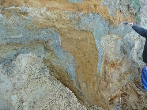
A pod of chalk within the deformed Happisbuirgh Till in the Contorted Drift has been squeezed and sheared into sigmoidal forms. This phenomenon, known as 'boudinage' is a feature of high strain, more often associated with the rocks of high grade metamorphic belts.

The intense shearing within the tills of the Contorted Drift is shown here (above) by a small Chalk pod that has been stretched out and subsequently subjected to microfaulting (Riedel shearing). The irony is that without the tell-tale chalk the till would not look particularly deformed. In fact it is intensely sheared and highly deformed, almost to the point of homogeneity, like well made cake mixture.

A stream cuts a 'chine' in the cliffs below Beeston Regis Caravan Park and exposes nice clean sections through the tills of the Contorted Drift.
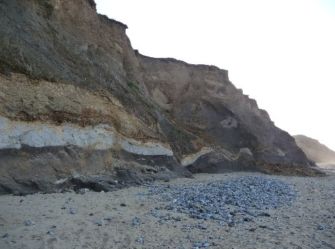 Image: A long raft of Chalk and super-incumbent Wroxham Crag have survived their entrainment in the Happisburgh Till. Photo courtesy of Russell Yeomans.
In the cliff are good sections of the Anglian tills (Contorted Drift) displaying banded diamictons in the lower part of the cliffs and highly contorted tills and sand pods in the upper part. At intervals along the cliff are prominent basins of sand several tens of metres across. A fresh interpretation (Phillips et al 2008) demonstrates that ice moving from the west to the east has deformed pre-existing glacial sediments pro-glacially, forming basins of deposition that have filled as the deformation has progressed. The limbs of the basins are bounded by prisms of till that have been up-thrust in the shortening process.
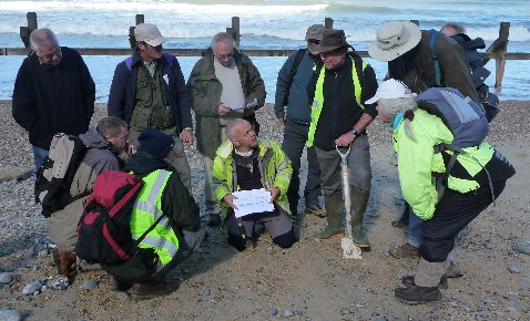
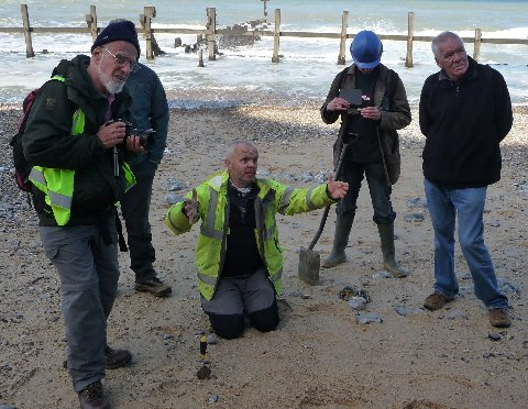 The master interpreter at work. Dr Emrys Phillips of the British Geological Survey, who has mapped and interpreted the cliff section from Weybourne to Runton, is explaining at the 2010 Geologists Association field meeting to West Runton how glacial ice was coming from the west and thrusting and deformed pre-existing drift and while also creating syngenetic sand basins that accumulated in the developing synclines. At this point, below the sand basin under the beach car park we are debating whether a sedimentary structure (below) is a fossil ice-wedge cast or a water-escape structure (he convinced us it was the latter).
References
H.F. Burke, E.R. Phillips, J.R. Lee, and Ian P. Wilkinson 2009. Imbricate thrust stack model for the formation of glaciotectonic rafts: an example from the Middle Pleistocene of north Norfolk, UK. Boreas 38 Issue, 620-637.
Jane K. Hart, 1987. The Genesis of the North East Norfolk Drift. PhD. Thesis UEA
E.R. Phillips, J.R. Lee, and H.F. Burke 2008. Progressive proglacial to subglacial deformation and syntectonic sedimentation at the margins of the Mid-Pleistocene British ice sheet: evidence from north Norfolk, UK. Quaternary Science Reviews. 27, 1848-1871
R.G. West, 1980. The pre-glacial Pleistocene of the Norfolk and Suffolk coasts. Cambridge University Press, 34-45
Compiled by Martin Warren. Last updated 14.1.2011