Field Guide to the Deep History Coast
West Runton - East Runton
Parking: car parks at both gaps; cafe and toilets at West Runton beach, amenities in East Runton. The proprietor makes a small charge in the except in winter. Pay at the Cafe if there is no attendant.
Access: from East Runton gap (TG 201428) or West Runton gap (TG 185432). Guided Geology Walks are available in 2011 from February to October.
Geology

This classic section is a Site of Special Scientific Interest and is frequently used for teaching.
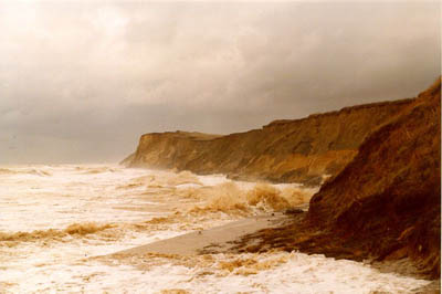 |  |
This is a good sign for fossil collectors. A stormy day and a high spring tide should clean up the West Runton Freshwater Bed nicely, freshly exposing another crop of fossils.
The West Runton Freshwater Bed
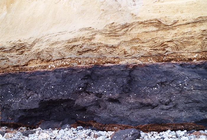
For 300m to the east of Woman Hythe (West Runton Gap) is the main outcrop of the type deposit of the Cromerian warm stage, the West Runton Freshwater Bed. It forms a prominent dark bed at the base of the cliff up to a maximum of 2m thick. It is highly fossiliferous and rich in the remains of plants and trees (seeds, cones, wood, fungi and pollen), molluscs (terrestrial and aquatic shells), fish (scales, teeth and bones), amphibians, large and small mammals (bones and teeth) and birds (bones). The WRFB spans the late Beestonian cold stage to the mid-Cromerian warm stage. Wanton digging is unproductive. Sieving and careful searching are recommended. Remember, this is a scientifically crucial site. Please help to conserve it and report any interesting finds to the Norfolk Museums Service (Cromer Museum 01263 513543 or Norwich Castle Museum and Art Gallery 01603 493625).
This is the site of a famous fossil find - the West Runton elephant (now called the West Runton Mammoth) Mammuthus trogontherii. A new monograph has been published by Elsevier Quaternary International, 228 (2010), consisting of a collection of papers by the many scientists who worked on the West Runton elephant excavation.
More detailed description of the West Runton Freshwater Bed is given here. Here is the faunal list for the West Runton Freshwater Bed
The West Runton Rhino
On 28 January 2015 a partial skull with two sets of tooth rows was discovered exposed by the tide in the West Runton Freshwater Bed, West Runton, Norfolk, England. The finder, Jonathan Stewart, made a preliminary investigation and partial excavation. Unfortunately it was late in the afternoon and darkness was threatening. Furthermore Jonathan was departing on vacation at 3am that night and he was unable to complete the dig, so he called me for assistance. 
References
Stuart, A.J. and Lister, A.M. , 2010. The West Runton Freshwater Bed and the West Runton Mammoth: Summary and conclusions. Quaternary International, 228 (2010). Elsevier 241-248.
Wroxham Crag
Weybourne Crag is an old term, used to describe mainly shallow marine facies, with sands, gravels and silts and clays that cover a long period of time through the Pre-Pastonian cold stage, the Pastonian warm stage and the Beestonian cold stage. These sediments are nowadays called the Wroxham Crag and underlie the West Runton Freshwater Bed.
Directly on the top of the Chalk is the Cromer Stone Bed and then the Weybourne Crag, which are often well cemented by iron pan and calcrete. When the West Runton eastern beach is heavily scoured by the tide, the exposed beds of Pastonian sands and gravels show strong saucer-shaped basins a few metres across and fossil ice-wedge casts, which may be attributed to the subsequent Beestonian cold stage.
Shelly sands, grey silts (when un-oxidised) and grey conglomerates of the Weybourne Crag (above) outcrop on the foreshore under Wood Hill and towards East Runton Gap and are attributed by West (1980) to the Pastonian and Pre-Pastonian stages. They have produced a fauna including voles, shrews, giant beaver, deer, elephant etc. This fauna is significantly older and more primitive than the succeeding Cromerian fauna of the West Runton Freshwater Bed.
Chalk, paramoudras and flint circles
The Paramoudra Chalk is only exposed at low water and the amount showing in these images is exceptional. Often much of the foreshore is covered by sand. In parts, the upper few centimetres of the Chalk on the shore platform are brecciated (broken in situ) due to subaerial periglacial conditions in the Lower Pleistocene, before the Cromer Stone Bed (Pre-Pa Ia) of the earliest Wroxham Crag were laid down on top of the Chalk.
On the low foreshore there are paramoudra flints (pot stones) and the related flint circles (occasionally double flint circles). These are trace fossils of an unknown creature inferred to be a worm-like thing named Bathychnis paramoudrae. Where a flint band outcrops across the beach (due to the easterly dip of the chalk) some of the flints are paramoudras that are are spaced 1 to 3 meters apart.
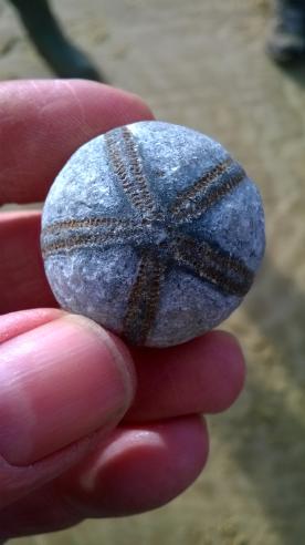
Fossil sea urchin Galerites hemisphaericus (Desor), preserved as an internal mould in flint, from the beach under Wood Hill, East Runton.
Wood Hill glaciotectonics
The 900m cliff section under Wood Hill has some of the most spectacular glaciotectonics in Europe. Rafts of Chalk, hundreds of metres long, have been thrusted and folded by ice moving from the north north west, raised up to 40m above beach level and incorporated within the Contorted Drift. In places some of the Weybourne Crag is carried on the Chalk rafts too.
To the west of Wood Hill is a large sand basin, which extends from the clifftop down almost down to the pre-glacial beds. There are also smaller basins and pods, incorporated in the Contorted Drift. Close to East Runton sea wall is a channel or basin of coarse boulder gravel at the top of the Contorted Drift. This is interpreted as a pro-glacial thrust stack.
Almost the whole section is underlain by the Cromer Forest-bed at the base of the cliff, and the fossiliferous Wroxham Crag below that on the foreshore (see the photo above).
Sharman Cutler's Stone and the rate of cliff erosion
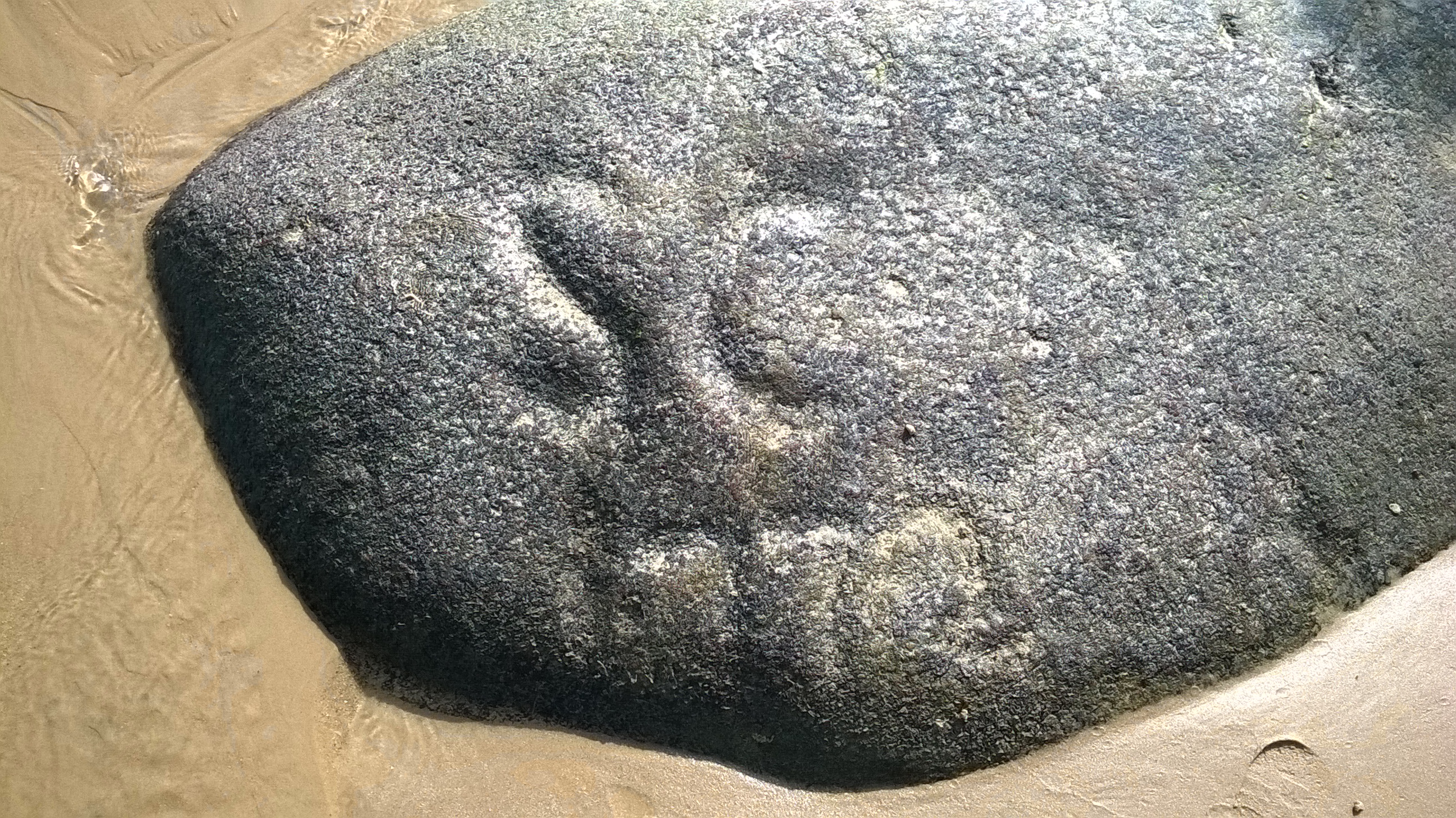
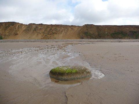
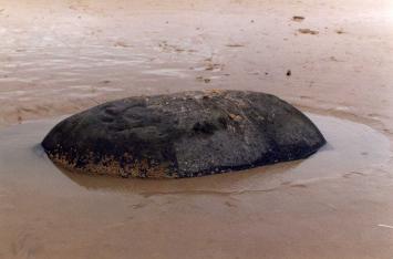 Opposite a point between Goss' Gap and Wood Hill lies a large round-backed stone (TG193432) (52°56'28.39"). It only appears at low water, on spring tides, half buried in the sand. Sometimes it is completely buried by sand. Made of a hard crystalline rock (probably not actually granite as stated below) it is evidently very resistant to erosion, for on its seaward side are some carved initials and a date. It says 'SC 1772', although it is very hard to tell most of the time. The large image below, taken on 27 August 2014 is the clearest I have ever seen it (contradicting Savin's date of 1770, below). It is an erratic rock carried to Norfolk from somewhere a long way to the north by the ice sheets of the Anglian glaciation (c. 450,000 years ago). It was left in the glacial drift when the ice melted and only in the 18th century cliff erosion caused it to fall to the beach below.
Alfred Savin, in his History of Cromer (1936), mentions this stone and tells us:
An interesting fact was recently brought to my notice by my friend, Mr. Vial Abbs. At West Runton, opposite the Chine in the cliff, which conveys the stream of water from the Brick Yard, and cuts through the well known Upper Freshwater Bed, is a large Glacial boulder of Granite, 100 yards from the cliff.
Mr. Abbs' father (born 1815) when a boy was shown this stone by his father. It was then at the foot of the cliff, and had the following initials and date cut in its face : 'S.CUTLER, 1770'. S[h]arman Cutler was a builder at Runton and Cromer (on Poor Rate 1767). It is a large stone some 5 feet in length and about 3 feet high. and lies on hard sand; The inscription is on the sea side. Its greatest value is showing the rate of coast erosion. Many Geologists have tried to calculate this and they vary from one yard to three yards per year for all the Norfolk coast.
I measured the distance from the stone to the base of the cliff on 8 February 2011 and found it to be 146m. Dividing the distance by the apparent time elapsed gives an average rate of erosion since the 18th century at 0.61m per annum. This does not accord with Savin (too little erosion), nor the evidence from historic maps (too much erosion), which indicates a rate of only 28 cm of erosion per annum over the last couple of centuries. Evidently, either the stone has moved, or it was not right at the bottom of the cliff when it was carved! The wave-cut shore platform slopes gently seawards and if there is going to be any creep of this very heavy stone it will be down hill northwards - hence exaggerating the rate of erosion. I fancy it is a bit of both.
Using the online Tithe map for West Runton, dated 1838, although possibly not legally accurate, gives a distance from the road at Oxwell Cross (near the old brick yard, which in the present day is Rocky Bottoms restaurant) to Goss' Gap as 400m. The 2014 Ordnance Survey measures it as 350m. Dividing one by the other: 50 metres erosion / 176 years = 284mm (about 11 inches) a year.
St. George's Rock
 Closer to East Runton Gap, a short distance (about 250m from the cliff base) offshore from Wood Hill (TG198431) there lie some rectangular blocks heaped one upon another. In modern times I have heard them referred to as (St.) George's Rock but the fishermen no longer know why it is so-called. Exposed only at low water, they are a favourite perch for cormorants. On one occasion I was at the helm of the Cromer inshore lifeboat on exercise and heading for Sheringham when I quite forgot about this pile of stone. We passed at high speed within inches of the barely submerged rocks. It was a close shave; I nearly wrecked the ILB. When viewed up close, the blocks are clearly of dressed stone, covered in weed and barnacles. One supposes that perhaps they were once cargo or ballast in the hold of a wooden ship (perchance the St George?) and destined for some coastal civil engineering project, perhaps a harbour, when she foundered on the lee shore at Runton. The ship would have quickly broken up (witness the Agenoria shipwrecked at Cromer in 1868 that broke up on the shore within a day or two). Now the ship has disappeared altogether, leaving her cargo stacked almost as it was in her hold. All this is supposition. If anyone knows the story of these rocks, would they please get in touch.
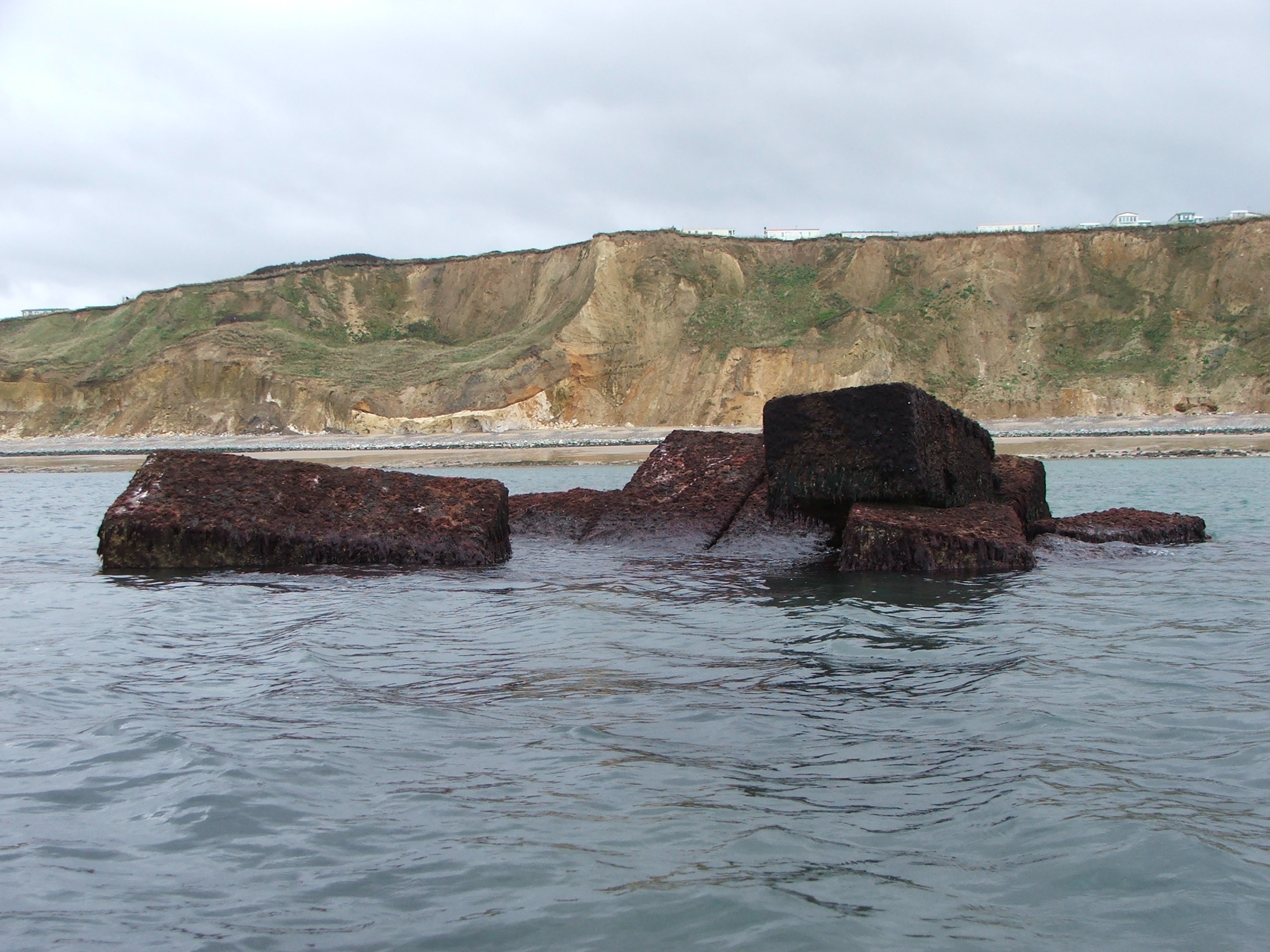
Click image to enlarge.
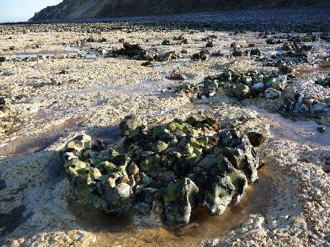
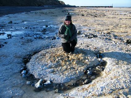
Black Meg
The First Edition Ordnance Survey 6 inch map shows the name 'Black Meg' adjacent to a ring of rocks at low water mark northeast of Goss' Gap. There is still a ring of flint rocks that enclose a large seawater pool today and it is possible to walk right around them and back to the beach at low spring tides. They may result from a slight doming of the chalk at this point that causes the outcrop of a flint band to make the ring. This then catches loose flints and creates the reef.

Click image to enlarge.